06 Dec 2023 Cyclone – Michaung
This article covers ‘Daily Current Affairs’ and the topic details ‘Cyclone Michaung.’ This topic has relevance in the Disaster Management section of the UPSC CSE exam.
Why in the news?
Recently, rain began to pummel several districts in Tamil Nadu and Andhra Pradesh as Cyclone Michaung intensified into a super cyclonic storm, causing a large amount of loss to lives and properties.
Current status of cyclone Michaung:
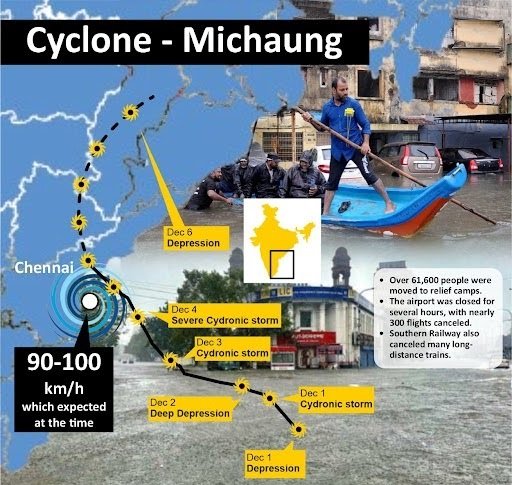
- On December 3, rains began to pummel Chennai as Cyclone Michaung, soon to intensify into a super cyclonic storm, parked itself roughly 100 km east of the city. By the next morning, most areas had recorded more than 120 mm of rain, with a few recording more than 250 mm. The storm, centered around 80 km southeast of Nellore and 120 km north-northeast of Chennai at 5.30 pm on December 4, moved northward along the Andhra Pradesh coast, bringing heavy rain to most of Tamil Nadu, parts of Andhra Pradesh, and southern Odisha.
- According to the statement of the India Meteorological Department (IMD), cyclonic storm Michaung intensified into a ‘severe cyclonic storm’ with a maximum sustained wind speed of 90 to 100 kmph and gusting to 110 kmph on December 4 afternoon.
- The A.P. State Disaster Management Authority (APSDMA) stated that the cyclone is likely to weaken in the next few hours. However, heavy rain will continue for a few more hours.
What is a Cyclone?
Cyclone is a region of low atmospheric pressure surrounded by high atmospheric pressure resulting in swirling atmospheric disturbance accompanied by powerful winds.
Preparedness:
- Over 61,600 people were moved to relief camps.
- Suspension and cutoff of power supply were taken as a precautionary measure.
- The airport was closed for several hours, with nearly 300 flights canceled.
- Southern Railway also canceled many long-distance trains.
- The IMD has issued a red alert for a few districts that will receive extremely heavy rainfall on 5 December and marked red are West Godavari, Konaseema, Eluru, Prakasam, Krishna, NTR, Bapatla and Guntur.
- The districts that are likely to receive very heavy rainfall and marked orange are: East Godavari, Kakinada, YSR Kadapa, Nellore and Alluri Sitaramaraju.
- The north coastal Andhra Pradesh region, as well as Tirupati, Annamayya and Nandyal, is marked yellow, as it is expected to receive heavy rainfall.
- The government declared a holiday for educational institutions on 5 December and advised private companies to permit employees to work from home.
Consequences of Cyclone Hazard
- Loss of life: Seven people in Chennai and five people in Andhra Pradesh were killed.
- Destruction of infrastructure: Parked vehicles were either marooned or floating, and there was uprooting of electric poles, along with a few instances of walls and roofs of houses collapsing.
- Inundation of seawater: Occurred in low-lying areas of coastal regions, resulting in the brimming of water bodies and the release of surplus water from reservoirs.
- Landfall: Between Nellore and Machilipatnam in Andhra Pradesh.
- Loss of vegetation, crops, and food supplies: Uprooting of a large number of trees.
- Severe disruption in communication and transportation: Included the shutdown of Chennai airfield, railways and roadways.
Post Disaster Relief:
- The Army and the NDRF rescued residents on boats in some areas.
- Additional workforce and necessary additional equipment are being sourced from neighbouring districts to undertake relief operations in Chennai and Andhra Pradesh.
- State agencies, including the Fire and Rescue Services and police personnel were involved in relief and rescue operations.
- Around 13 Ministers were deputed to oversee relief and rescue operations, besides deploying more senior IAS officers on the field.
Favorable Conditions: Listed below are some of the identified favorable conditions:
- A warm sea surface (temperature in excess of 26–27°C) and associated warming extending up to a depth of 60m with abundant water vapor in the overlying air (by evaporation).
- High relative humidity in the atmosphere up to a height of about 5,000 meters.
- Atmospheric instability that encourages the formation of massive vertical cumulus clouds due to the condensation of rising moist air.
- Low vertical wind shear between the lower and higher levels of the atmosphere does not allow the heat generated and released by the clouds to be transported from the area (vertical wind shear is the rate of change of wind between the higher and lower levels of the atmosphere).
- The presence of cyclonic vorticity (rate of rotation of air) that initiates and favors the rotation of the air cyclonically.
- Location over the ocean, around 5–25° latitude away from the equator.
Cyclone Risks in India
- In India, 8 percent of the total landmass is prone to cyclones. India has a coastline of about 7,516 km, with 5,400 km along the mainland, 132 km in Lakshadweep, and 1,900 km in the Andaman and Nicobar Islands.
- Four states (Tamil Nadu, Andhra Pradesh, Orissa, and West Bengal) and one Union Territory (Puducherry) on the east coast, and one state (Gujarat) on the west coast, are highly vulnerable to cyclone disasters.
- There are 13 coastal states and Union Territories (UTs) in the country, encompassing 84 coastal districts affected by tropical cyclones.
- More cyclones occur in the Bay of Bengal than the Arabian Sea, with the ratio approximately 4:1.
Cyclone Warning System in India
Low pressure and the development of cyclones can be detected hours or days before they cause damage. Satellites track the movement of these cyclones, based on which people are evacuated from areas likely to be affected. However, predicting accuracy is challenging, and accurate landfall predictions can only provide a few hours’ notice to threatened populations.
India has one of the best cyclone warning systems in the world. The India Meteorological Department (IMD) is the nodal department for wind detection, tracking, and forecasting cyclones. Cyclone tracking is done through INSAT (Indian National Satellite) satellites. Cyclone warnings are disseminated through various means, such as satellite-based disaster warning systems, radio, television, telephone, fax, high-priority telegram, public announcements, and bulletins in the press. These warnings are communicated to the general public, the fishing community, especially those at sea, port authorities, and commercials.
Cyclone Hazard Mitigation
- Cyclone Shelters: Use public buildings in densely populated coastal areas as cyclone shelters, designed with a blank façade and minimal apertures facing prevailing winds. The shorter side of buildings should face the storm for less wind resistance, with earth berms and green belts to reduce impact.
- Rapid dissemination of warnings, especially to government agencies and marine entities;
- Coastal Belt Plantation: Establish green belts to act as a buffer against strong winds and floods, sustaining less damage. Forests provide a wide buffer zone, hindering cyclones from freely traveling inland.
- Hazard Mapping: Utilize meteorological records to create hazard maps, illustrating areas vulnerable to cyclones, estimating severity, and predicting damage intensities in a region.
- Land Use Control: Designate vulnerable areas for least critical activities, regulate land use through policies, and enforce building codes. Avoid settling in floodplains and mark key facilities in land use plans.
- Flood Management: Incorporate flood mitigation measures to address torrential rains, strong winds, storm surges, and potential landslides in cyclone-affected areas.
- Improving Vegetation Cover: Plant trees and maintain vegetation to secure soil, prevent erosion, slow runoff, and act as windbreaks.
- Coastal Shelterbelt Plantations: Develop shelterbelt plantations along the coast to break severe wind speeds and minimize devastating effects.
Download Yojna daily current affairs eng med 6th Dec 2023
Q. Which of the following can be considered as some initial conditions for the emergence of a tropical cyclone?
- Strong Coriolis force
- Large variations in the vertical wind speed
- A pre-existing weak low-pressure area
Select the correct answer using the codes below:
(a) 1 and 3 only
(b) 1 only
(c) 2 and 3 only
(d) 1 and 3 only
ANSWER: A
Q. How can Disaster Resilient Infrastructure be comprehended as a means to minimize the loss of life and property during cyclone-associated events? Additionally, explore the challenges associated with securing essential infrastructure in the aftermath of a cyclone.
No Comments